Revealing the strongest commercial remote sensing satellite in the history of China: the resolution reaches 0.5 meters.
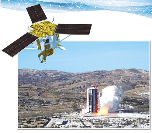
On December 28th, 2016, two satellites of Group 01 of Gaojing-1 were successfully launched in Taiyuan Satellite Launch Center with one arrow and two stars. (Xinhua News Agency)
On December 28, 2016, two satellites in Group 01 of Gaojing No.1 in China were successfully launched in the form of one arrow and two stars. As of January 10, 2017, the ground system has successfully received and processed 15 tracks of 1241 images. Since then, there have been two China-born "space detectives" in the vast universe.
As China’s first self-developed 0.5-meter high-resolution commercial remote sensing satellite, what unique skills does Gaojing-1 have and what is the significance of its launch? Please follow the footsteps of the Economic Daily reporter and approach the strongest commercial remote sensing small satellite in China’s history.
Break through the monopoly of remote sensing market
Looking down at Gaofen No.1, which covers 800 kilometers, we can bring the spatial resolution of China remote sensing satellite into Gaofen No.2 in the Ami era, and we can observe and image Gaofen No.3 & HELIP; …
Looking back at the remote sensing satellites launched in recent years, many people still remember them. However, the "protagonist" Gao Jing No.1, who is going to appear today, belongs to the remote sensing family, but it is more grounded. "In the past, China’s remote sensing satellites mostly provided public welfare services for the government and other departments, and Gaojing No.1 will provide more professional and quantitative remote sensing data for various commercial users." Xu Wen, general manager of China Siwei Surveying and Mapping Technology Co., Ltd., a specialized company of China Aerospace Science and Technology Corporation, which is responsible for the commercial operation of Gaojing No.1, said.
This positioning is not only the requirement of realizing the independent supply of data, but also has practical considerations. With the continuous development of technology application, the value of remote sensing has been continuously explored. The commercial remote sensing satellite companies, such as Digital Earth and Airbus, which have stood out from the market several times, have monopolized the high-resolution commercial remote sensing market in China.
According to the data provided by Xu Wen, China’s annual direct consumption of satellite raw data with resolution better than 2.5 meters is about 500 million yuan, and the growth rate is about 8%, of which foreign satellite data accounts for 75% of the market. What is even more difficult is that in the remote sensing data market, data with sub-meter level or above, especially with resolution better than 0.5 meters, is the mainstream consumption index. However, in the past, due to the performance of independent commercial remote sensing satellites, none of China’s commercial remote sensing satellites had a resolution of 0.5 meters.
In the 21st century, the application industry of remote sensing satellites serving various fields of national economy and social development is showing great growth. Xu Wen frankly said that because there is no right to speak, sometimes, even at a high price, you can’t buy much-needed sub-meter data.
Faced with some heavy reality, in September 2015, with the approval of the Ministry of Finance, Aerospace Science and Technology Group established a commercial remote sensing satellite company. Since then, Aerospace Dongfanghong Satellite Co., Ltd. has completed the development of two satellites in the 01 group of Gaojing-1 in 17 months. At the end of 2016, with the launch of these two satellites in Taiyuan, the situation that China’s commercial remote sensing was controlled by people came to an end.
"The successful launch of Gaojing No.1 has achieved a breakthrough in the commercialization of China’s domestic remote sensing satellite operation mode. Since then, China has owned independent remote sensing data with a resolution of 0.5 meters high." Jia Ke, director of the Party-mass Work Department of China Aerospace Science and Technology Corporation, said.
What does a resolution of 0.5m mean? This is a watershed in the global high-resolution commercial remote sensing satellite market. Previously, only the United States and South Korea reached this level. "The successful launch of Gaojing-1 marks that domestic commercial remote sensing satellites have officially entered the international first-class ranks." Zhang Xiaomin, deputy general manager of Aerospace Dongfanghong Satellite Co., Ltd. said.
For the general public, the most intuitive feeling is that the satellite is smaller and smaller. Taking crop monitoring as an example, it can not only identify the growth of crops, but also distinguish the subtle differences of crop colors in different periods. Compared with ordinary remote sensing satellites, the clarity is like the difference between high-definition TV and ordinary TV.
This special feature determines that Gaojing-1 is different. "It can not only collect more delicate details of ground objects, but also be suitable for high-precision map making, change monitoring and impact depth analysis. It can also shoot in a large width, which has unique advantages for large-area surface observation and environmental monitoring." Zhang Xiaomin said.
Small expert in space "gymnastics"
Resolution is only one of the parameters to measure the level of a satellite. For the satellite, it is also very important to make a large-angle attitude turn according to the actual needs, and quickly restore stability, image the target, and then obtain high-quality images.
To realize this feature, the satellite needs to "turn fast" and "turn steadily". However, it is not easy to have both fish and bear’s paw. In order to rotate fast, the torque output by the satellite’s actuator has to be large, but the inertia is small when the torque is large, and the satellite is not easy to stabilize quickly, which can not provide the necessary attitude stability conditions for high-resolution imaging.
Gaojing-1, with a single star weighing only 500 kilograms, did it. Zhang Xiaomin said that Gaojing-1 adopted the newly developed variable-speed control moment gyro in China. In the past, the combination of momentum wheel and control moment gyro was used for satellite attitude control. Momentum wheel is like the open arms of a balance beam athlete. It can adjust or stabilize the attitude of the satellite by adjusting the speed of the internal high-speed rotating wheel. Although it has high accuracy, its strength is small and its adjustment speed is slow. The control moment gyro can adjust the attitude of the satellite by adjusting the direction of the rotating shaft of the high-speed rotating wheel, which can provide "the power of the wild" and speed up the adjustment, but the accuracy is slightly poor.
The variable speed control moment gyro combines the advantages of both, which can be used as both a control moment gyro and a momentum wheel. When working in the "control moment gyro" mode, the attitude of the satellite can be adjusted quickly, and when working in the "momentum wheel" mode, the satellite can be stabilized accurately, and it can also be switched smoothly between the two modes. In this way, in the aspect of attitude control, Gao Jing-1 is like an all-around space gymnast, who can "move like a rabbit" or "be quiet like a virgin" instantly.
The two satellites launched this time are only some members of the Gaojing No.1 family. According to the established plan, two satellites of Gaojing-1 Group 02 will be completed and put into the market before the middle of 2017. "Four commercial remote sensing satellite constellations with a spatial resolution of 0.5 meters are the first in the world." Xu Wen said.
The so-called constellation is a name relative to a single satellite. What is the significance of this multi-star combination? Xu Wen has a relatively popular explanation: the earth is turning, and the satellites are also turning. It usually takes several days for a single satellite to repeatedly observe the same feature. Because common remote sensing satellites operate in low orbit to ensure spatial resolution, the observation area is relatively small, and it is impossible to continuously observe the same place, so they can only take photos when passing over the point. With the constellation, it is easier to revisit the old place in a short time.
Xu Wen said that the design of Gaojing-1 constellation aims to solve two main problems, one is to repeatedly observe the same feature, and the other is to realize dynamic observation. In terms of disaster and environmental monitoring and forecasting, the 0.5-meter high-resolution remote sensing satellite constellation has more advantages. For example, when an earthquake occurs, it may take a day or two to receive the data of the disaster area. Now, after forming a constellation, it takes only one or two hours to know the situation of the disaster area.
According to the design, after the four remote sensing satellites with a resolution of 0.5 meters are networked and operated in 2017, they can revisit any place in the world once a day, which means that as long as the weather conditions are good, the landscape of any region in the world can be panoramic.
Going abroad will be expected.
Moreover, in terms of the number of satellites, types of earth observation, collection capacity, etc., the constellation will also have the international first-class level: the daily collection capacity will reach 3 million square kilometers, and it can cover ten domestic cities (Beijing, Shanghai, Guangzhou, Shenzhen, Tianjin, Chongqing, Shenyang, Chengdu, Xi ‘an and Wuhan) once every three days.
More importantly, thanks to the construction of constellations, the spatial resolution of Gaojing-1 will be increased from the current 0.5 meters to 0.4 meters or even 0.3 meters. This index will approach the highest level of commercial remote sensing satellites at present, that is, 0.31 meters.
Of course, this is only the first step. According to Yang Yike, director of the Aerospace Department of China Aerospace Science and Technology Corporation, Gaojing-1 is only the first star of the first phase of commercial remote sensing "16+4+4+X" system construction. According to the plan, the "16+4+4+X" commercial remote sensing satellite system will be built around 2022. The system includes 16 high-resolution optical satellites with 0.5m resolution, 4 high-end optical satellites, 4 synthetic aperture radar satellites and several remote sensing satellite constellations combined with hyperspectral and video satellites. After the system is finally completed, the daily collection capacity will reach 12 million square kilometers, and it can cover ten major cities in China once a day. With the all-weather and all-day observation ability of radar satellites, it can achieve hourly high-resolution remote sensing data acquisition.
Talking about the future of Gaojing-1, Xu Wen said that Gaojing-1 will be delivered to Beijing Aerospace Shijing Technology Co., Ltd., a subsidiary of China Siwei Surveying and Mapping Technology Co., Ltd., for data promotion. Satellites will provide high-quality services in land and resources investigation, surveying and mapping, environmental monitoring, etc., and may also be used in new markets — — Urban construction planning, real estate investment, industrial facilities evaluation, finance and insurance, Internet industry and many other aspects show their talents, providing satellite data for industry-level and individual consumer users. For example, in the insurance field, Digital Earth has worked together with its partners to help insurance companies quickly and accurately estimate losses after disasters.
"Thanks to the improvement of resolution, Gaojing No.1 can send back a large number of valuable high-definition remote sensing images as needed, bringing the public into the era of reading pictures in space." Xu Wen said.
On the basis of consolidating the domestic market, Gaojing No.1 will also actively go abroad. Xu Wen revealed that Gaojing-1 will provide global users with all-weather remote sensing data services and application system solution services, accelerate the transformation of existing domestic remote sensing satellites into "market business", and lead the marketization, industrialization and internationalization of independent remote sensing satellites. In the future, it will also provide high-quality remote sensing satellite data and value-added services to domestic and foreign customers. (Shen Hui)